Regulations (Section 1)
1. A
You may operate an sUAS from a moving vehicle if you are in a sparsely populated area and the driver does not serve as the remote PIC, person manipulating the controls, or visual observer. Reference: 14 CFR 107.25
2. C
You may not operate a small unmanned aircraft directly over another person unless that person is directly involved in the operation (such as a visual observer or other crewmember) or within a safe cover, such as inside a stationery vehicle or a protective structure that would protect a person from harm if the small unmanned aircraft were to crash into that structure. Reference: 14 CFR 107.39
3. C
This scenario is not compliant with Part 107. You may not operate over non-participants without safe cover and you may not drop objects in a manner that creates hazard.
4. A
A remote pilot-in-command must be used during Part 107 sUAS operations. A visual observer is optional. The person manipulating the controls may be the remote PIC, or must be operating under the direct supervision of the remote PIC.
Reference:14 CFR 107.19
5. B
A person may not operate or act as a remote pilot-in-command or visual observer in the operation of more than one unmanned aircraft at the same time.
6. B
An unmanned aircraft means an aircraft operated without the possibility of direct human intervention from within or on the aircraft. Reference: 14 CFR 107.1, 107.3, AC 107-2
7. C
No items may be dropped from the small unmanned aircraft in a manner that creates undue hazard to persons or property. Reference: 14 CFR 107.23
8. B
The sUAS cannot be flown faster than a ground speed of 87 knots (100mph) and must be operated below 400 feet.
Reference: 14 CFR 107.51
9. A
Except in an emergency, no person may operate an aircraft contrary to an ATC clearance or instruction.
Reference: 14 CFR 107.21
10. B
“Owners must register the sUAS if it is greater than 0.55 lbs, less than 55 pounds and operated under the provisions of the 14 CFR Part 107.
Reference: 14 CFR 107.13”
11. C
“When sUAS operations are conducted during civil twilight, the sUAS must be equipped with anticollision lights that are capable of being visible for at least 3 statute miles. Reference: 14 CFR 107.29”
12. A
“Lithium batteries that are installed in an sUAS for power during the operation are not considered a hazardous material under Part 107. However, spare (uninstalled) lithium batteries would meet the definition of hazardous material and may not be carried on the sUAS. Reference: AC 107-2”
13. B
“In case of an in-flight emergency, the remote PIC is permitted to deviate from any rule of Part 107 to the extent necessary to respond to that emergency.
Reference: 14 CFR 107.21”
14. A
“Although not required by Part 107, the FAA encourages applicants to submit their application at least 90 days prior to the start of the proposed operation. The FAA will strive to complete review and adjudication of waiver within 90 days; however, the time required for the FAA to make a determination regarding waiver requests will vary based on the complexity of the request. Reference: AC 107-2”
15. C
“The remote PIC must report any sUAS accident to the FAA, within 10 days of the operation, if a serious injury to any person or any loss of consciousness occurs. It would be considered a serious injury if a person requires hospitalization.
Reference: 14 CFR 107.9, AC 107-2”
16. C
“Remote pilot certificate holders with an sUAS rating must meet the recurrent training requirements after 24 months. This retraining can be satisfied by completing the online FAA course or taking the FAA knowledge exam.
Reference: 14 CFR Part 107.63 and 107.65; AC 107-2”
17. B
“The sUAS must remain within visual line of sight (VLOS) of flight crewmembers. The VLOS requirement would not prohibit actions such as scanning the airspace or briefly looking down at the sUAS control station. Should the remote PIC or person manipulating the controls lose VLOS of the small UA, he or she must regain VLOS as soon as possible.
Reference: 14 CFR 107.31”
18. B
“The remote pilot application must be submitted to a Flight Standards District Office (FSDO), a designated pilot examiner (DPE), an airman certification representative for a pilot school, a certified flight instructor (CFI), or other person authorized by the Administrator to process the application. Reference: 14 CFR 107.63 and 61.56”
19. C
“The remote PIC or person manipulating the flight controls of an sUAS must comply with the “”do not operate while impaired”” regulations.
Reference: 14 CFR 107.19 (b), 107.19(d) and 107.57″
20. C
“Owners must register the sUAS if it is greater than 0.55 lbs, less than 55 pounds and operated under the provisions of the 14 CFR Part 107.
Reference: 14 CFR 107.13”
21. C
“Each remote pilot shall, before each flight, assess the operating environment including local weather condition, local airspace and any flight restrictions, the location of persons and property on the surface, and other ground hazards. Reference: 14 CFR 107.49”
22. B
“As little as one ounce of liquor, one bottle of beer, or four ounces of wine can impair flying skills. Reference: AIM 8-1-1”
23. A
“The remote PIC must be able to maneuver the sUAS to avoid a collision and prevent other aircraft from having to take evasive action.
Reference: 14 CFR 107.37”
24. A
14 CFR Part 107 does not apply to model aircraft that meet the criteria in 14 CFR 101.41, amateur rockets, moored balloons or unmanned free balloons, kites, operations conducted outside the United States, public aircraft operations, and air carrier operations.
25. B
“The sUAS must be registered by a person who is at least 13 years of age
Reference: 14 CFR 107.13, 91.2013”
26. C
“A remote pilot-in-command, owner, or person manipulating the flight controls of a small unmanned aircraft must, upon request, make available to the administrator: (1) the remote pilot certificate with a small UAS rating; and (2) any other document, record, or report required. Reference: 14 CFR 107.7”
27. A
“A person who does not hold a remote pilot certificate or a remote pilot that has not met the recurrent testing/training requirements of part 107 may operate the sUAS under Part 107, as long as he or she is directly supervised by a remote PIC and the remote PIC has the ability to immediately take direct control of the sUAS. Reference: 14 CFR 107.12”
28. B
“This sUAS operation is subject to 14 CFR part 107 because the aerial imagery is for the furtherance of a business, making it commercial in nature.
Reference: 14 CFR 107.3”
29. A
“The remote PIC must complete a preflight familiarization, inspection, and other actions, such as crewmember briefings, prior to beginning flight operations.
Reference: 14 CFR 107.49 ”
30. B
“the sUAS cannot be flown higher than 400 feet AGL unless flown within a 400-foot radius of a structure and is not flown higher than 400 feet above the structure’s immediate upper-most limit. Reference: 14 CFR 107.51”
31. C
“The FAA has stated that they will not provide waivers for beyond VLOS during the carriage of goods for hire. Also, moving vehicles (land or sea) are not authorized to be used during flights upon which goods are carried for hire. Reference: AC 107-2”
32. C
“Each remote PIC who deviates from a rule in Part 107 must, upon request of the FAA administrator, send a written report of that deviation to the Administrator
Reference: 14 CFR 107.21”
33. A
“Report any sUAS accident to the FAA within 10 days if it results in serious injury, loss of consciousness, or repairs costing over $500.
Reference: 14 CFR 107.9”
34. B
“14 CFR 65.20 states that any person who falsifies or makes a fraudulent entry in a logbook, report or record is subject to the suspension or revocation of any airman or ground instructor certificate or rating held by that person. Reference: 14 CFR 107.6”
35. A
“No person may act as a pilot-in0command (PIC), or in any other capacity as a required pilot flight crewmember when operating a sUAS unless he or she has in possession or readily accessible a current-pilot certificate.
Reference: 14 CFR 107.7”
36. B
“A remote pilot may not act as pilot-in-command of an sUAS at night. A remote pilot must land by the end of evening twilight.
Reference: 14 CFR 107.29”
37. A
“Each remote PIC who deviates from a rule in Part 107 must, upon request of the FAA administrator, send a written report of that deviation to the Administrator
Reference: 14 CFR 107.21”
38. C
“No person may manipulate the flight controls of a small unmanned aircraft system or act as a remote pilot-in-command, visual observer, or direct participant in the operation of the small unmanned aircraft if he or she knows or has reason to know that he or she has a physical or mental condition that would interfere with the safe operation of the small un manned aircraft system.
Reference: 14 CFR 107.17 ”
39. A
“A refusal to submit to a test to indicate the percentage by weight of alcohol in the blood, when requested by a law enforcement officer, or a refusal to furnish or authorize the release of the test results requested by the Administrator, is grounds for denial os an application for a remote pilot certificate with a small UAS rating for a period of up to 1 year after the date of that refusal; or suspension or revocation of a remote pilot certificate with a small UAS rating. Reference: 14 CFR 107.59”
40. B
“No person may act, or attempt to act, as a crewmember of a civil aircraft while having .04 percent or more, by weight alcohol in the blood.
Reference: 14 CFR 107.27,91.17”
41. C
“The remote PIC must hold a Part 107 remote pilot certificate with an sUAS rating before conducting any sUAS operation Reference: 14 CFR 107.12”
42. C
“The sUAS cannot be flown faster than a ground speed of 87 knots (100mph). Reference: 14 CFR 107.51”
43. A
“The visual observer (when asked by the remote PIC) maintains visual line of sight with sUAS and reports any potential hazards to the remote PIC and person manipulating the controls. Reference: 14 CFR 107.33”
44. A
“small unmanned aircraft (sUAS) means an unmanned aircraft weighing less than 55 pounds on takeoff, including everything that is on board or otherwise attached to the aircraft. Reference: 14 CFR 107.1,AC 107-2”
45. C
“Operation of an sUAS is permitted from a moving land or waterborne vehicle over a sparsely populated (or unpopulated) area.
Reference: 14 CFR 107.25”
46. A
“Operation of an sUAS is permitted from a moving land or waterborne vehicle over a sparsely populated (or unpopulated) area. Reference: 14 CFR 107.25”
47. B
“If the remote PIC determines that the operation cannot be conducted within the regulatory structure of Part 107, he or she is responsible for applying for a Certificate of Waiver (COW) and proposing a safe alternative to the operation. This COW with allow an sUAS operation to deviate from certain provisions to Part 107 as long as the FAA finds that the proposed operation can be safely conducted under the terms of that Certificate of Waiver.
Reference: 14 CFR 107.200”
48. A
“Report any sUAS accident to the FAA within 10 days if it results in serious injury, loss of consciousness, or repairs costing over $500.
Reference: 14 CFR 107.9”
49. C
“Part 107 regulates commercial sUAS operations.
Reference: 14 CFR 107.41 and 107.1”
50. A
“You may not operate a small unmanned aircraft directly over another person unless that person is directly involved in the operation (such as a visual observer or other crewmember) or within a safe cover, such as inside a stationery vehicle or a protective structure that would protect a person from harm if the small unmanned aircraft were to crash into that structure.
Reference: 14 CFR 107.39”
51. B
“No person may manipulate the flight controls of a small unmanned aircraft system or act as a remote pilot-in-command, visual observer, or direct participant in the operation of the small unmanned aircraft if he or she knows or has reason to know that he or she has a physical or mental condition that would interfere with the safe operation of the small un manned aircraft system. Reference: 14 CFR 107.17 ”
52. B
“The remote PIC also has a responsibility to remain clear of and yield right of way to all other aircraft, manned or unmanned, and avoid other potential hazards that may affect the remote PIC’s operation of the aircraft.
Reference: 14 CFR 107.37”
53. A
“No report is required because the damage can be repaired for less than $500. A report is required only when damage to any property, other than the small UA, is greater than $500 to repair or replace the property (whichever is lower). The cost of the sUAS is not considered when determining if an event is considered to be an accident or incident.
Reference: 14 CFR 107.9, AC 107-2”
54. C
“The remote PIC is ultimately responsible for assessing the needs of the operation and preparing sufficient support crewmembers to ensure the safety of the operation.
Reference: 14 CFR 107.12”
55. B
“The holder of a remote pilot certificate who has made a change in his or her permanent mailing address may not, after 30 days from the date moved, exercise the privileges of his or her certificate
unless he or she has notified in writing the FAA Airmen Certificate Branch Reference: 14 CFR 107.77”
56. A
“No person may act or attempt to act as a crewmember of a sUAS within 8 hours after the consumption of any alcoholic beverage. Remember “”8 hours bottle to throttle””
Reference: 14 CFR 107.27, 91.17″
57. B
“The sUAS cannot be flown higher than 400 feet AGL unless flown within a 400-foot radius of a structure and is not flown higher than 400 feet above the structure’s immediate upper-most limit. Reference: 14 CFR 107.51”
58. B
“A non-certified person may manipulate the controls of the sUAS only if he or she is under the direct supervision of the remote PIC.
Reference: 14 CFR 107.12”
59. C
“The remote pilot operating an sUAS must yield right-of-way to all other manned aircraft, including aircraft operating on the surface of the aircraft.
Reference: 14 CFR 107.37”
60. A
“Part 107 sUAS operations require minimum visibility of 3 SM and the minim distance from clouds must be no less than 500 feet below the cloud and 2000 feet horizontally from the cloud. To maintain 500 feet below the cloud, you must have a 900 foot ceiling to be able to operate to the maximum 400 AGL, or a ceiling that would allow the sUAS to operate at a lower AGL altitude. Reference: 14 CFR 107.51”
61. C
“this sUAS operation is not subject to FAA sUAS regulations because the sUAS operation is recreational in nature. Part 101 details the regulations pertinent to model aircraft and hobby operations. Reference: 14 cfr Part 107.3”
62. B
“You may not operate a small unmanned aircraft directly over another person unless that person is directly involved in the operation (such as a visual observer or other crewmember) or within a safe cover, such as inside a stationery vehicle or a protective structure that would protect a person from harm if the small unmanned aircraft were to crash into that structure.
Reference: 14 CFR 107.39”
63. A
“This sUAS operation is subject to 14 CFR Part 107 because the compensation (money or otherwise) makes the operation commercial in nature
Reference: 14 CFR 107.3”
64. B
“Prior to flight, the remote PIC must ensure that all persons directly participating in the small unmanned aircraft operation are informed about the operating conditions, emergency procedures, contingency procedures, roles and responsibilities, and potential hazards.
Reference: 14 CFR 107.49, AC 107-2”
65. B
“An autonomous operation does not negate the requirement for a remote PIC. An autonomous operation is generally considered an operation in which the remote pilot inputs a flight plan into the CS, which send it to the autopilot on the small UA. Reference: AC 107-2”
66. A
“This scenario is not compliant with Part 107. Visual aids such as binoculars may be used only momentarily to enhance situational awareness. they may not be used during the duration of the operation.
Reference: 14 CFR 107.31”
67. C
“The remote PIC is ultimately responsible for assessing the needs of the operation and preparing sufficient support crewmembers to ensure the safety of the operation.
Reference: 14 CFR 107.12”
68. B
“A conviction for the violation of any Federal or State statute relating to the growing, processing, manufacture, sale, disposition, possession, transportation, or importation of narcotic drugs, marijuana, or depressant or stimulant drugs or substances is grounds for suspension or revocation of a remote pilot certificate with a small UAS rating.
Reference: 14 CFR 107.57”
69. B
“A remote pilot may not act as pilot-in-command of an sUAS at night. Night is defined as the time between the end of evening civil twilight and the beginning of morning civil twilight. Morning civil twilight is the period 30 minutes prior to sunrise until sunrise. This means you can launch your sUAS operation 30 minutes prior to sunrise.
Reference: 14 CFR 107.29”
70. A
“Part 107 addresses sUAS operations of certain civil small unmanned aircraft within the National Airspace System.
Reference: 14 CFR Part 107”
71. B
“A remote pilot-in-command, owner, or person manipulating the flight controls of a small unmanned aircraft system must, upon request, make available to the Administrator: (1) the remote pilot certificate with a small UAS rating; and (2) any other document, record, or report required. Reference: 14 CFR 107.7”
72. A
“The Pilot’s Handbook of Aeronautical Knowledge (FAA-H-8083-25) provide information on the physiological effects of alcohol, prescription drugs, and over-the-counter medications. Reference: FAA-H-8083-25”
73. C
“A conviction for the violation of any Federal or State statute relating to the growing, processing, manufacture, sale, disposition, possession, transportation, or importation of narcotic drugs, marijuana, or depressant or stimulant drugs or substances is grounds for denial of an application for a remote pilot certificate with a small UAS rating for a period of up to 1 year after the date of that act.
Reference: 14 CFR 107.57”
Airspace (Section 2)
1. B
“No person may operate a small unmanned aircraft in prohibited or restricted areas unless that person has permission from the using or controlling agency, as appropriate.
Reference: Sectional Chart Legend, 14 CFR 107.45”
2. A
“Both the Aeronautical Information Manual (AIM) and the Pilot’s Handbook of Aeronautical Knowledge
(FAA-H-8083-25) contain explanations of airport signs and markings Reference: AIM Chapter 2, Section 3”
3. A
“Onawa, IA (K36) is in the bottom right quadrant of the sectional excerpt. It is outside any shading or
lines, which indicates the airport is in Class G airspace up to 1200 feet AGL Reference: Sectional Chart Legend”
4. B
“All activity within an Alert Area shall be conducted in accordance with FAA regulations, without waiver, and pilots of participating aircraft, as well as pilots transiting the area, shall be equally responsible for collision avoidance Reference: AIM 3-4-6”
5. C
“No person may operate a small unmanned aircraft in class B, Class C, or class D airspace or within the lateral boundaries of the surface area of Class E airspace designated for an airport unless that person has prior authorization from ATC
Reference: 14 CFR 107.41”
6. C
“VFR Military training routes at and below 1500 feet AGL (will no segment above 1500) will be identified by four digit numbers, eg VR1351. VR above and below 1500 feet AGL (segments of these routes may be below 1500) will be identified by three digit numbers, eg VR 426. Small UAS must operate below 400 feet. This 4 digit Military Training Route indicates operations below 1500 feet AGL, which could present a hazard to the sUAS operations. Reference: AIM 3-5-2”
7. B
“The chart supplement US includes airport details, including remarks unique to that airport. Figure 52 shown an abbreviated remark for Lincoln Airport “”Birds invof aipt””
Reference: Chart Supplement”
8. A
“When approaching the holding line from the side with the continuous lines, a pilot should not cross the holding line without ATC clearance at a controlled airport, or without making sure of adequate separation from other aircraft at uncontrolled airports. Reference: AIM 2-3-5”
9. A
“The dimensions of Class D airspace are as needed for each individual circumstance. The airspace may include extensions necessary for IFR arrival and departure paths. Reference: AIM 3-2-5”
10. C
“The chart supplement US includes airport details, including the airspace the airport lies in. Figure 31 shows Coeur D’ Alene airport within Class E airspace.
Reference: Chart Supplement”
11. A
“Runway hold markings are indicated by two double dashed and two solid yellow lines. You are considered to be on the taxiway on the double solid yellow line side while you are considered to be on the runway if on the double dashed yellow line side. Reference: AIM 2-3-4”
12. B
“When a manned aircraft is approaching to land at an airport in Class G airspace without an operating control tower, each pilot of an airplane will make all turns to the left unless the airport displays approved light signals of visual markings indicating that turns should be made to the right (which will be detailed in the Chart Supplement US)
Reference: 14 CFR 91.126”
13. A
“The “”98″” north of area 7 is the line of longitude east and west of the line that passes through Greenwich, England.
Reference: FAA-H-8083-25″
14. A
“Refer to Appendix 1, Legend 1. Airports having control towers are shown in blue, all others in magenta.
Reference: Sectional Chart Legend.”
15. C
“The GXF airport is surrounded by a dashed blue line which indicates it is within Class D airspace. Reference: Sectional Chart”
16. A
Restricted areas can be penetrated but only with the permission of the controlling agency. No person may operate an aircraft within a restricted area contrary to the restrictions imposed unless he/she has the permission of the using or controlling agency. Penetration of restricted areas without authorization
from the using or controlling agency may be fatal to the aircraft and its occupants Reference: 14 CFR 107.45, AIM 3-4-3
17. B
“Effective scanning is accomplished with a series of short, regularly spaced eye movements that bring successive areas of the sky into the central visual field. Each movement that brings successive areas of the sky into the central visual field. Each movement should not exceed 10 degrees and each area should be observed at least one second to enable detection. Reference: AIM 8-1-6”
18. A
“FDC NOTAMs are issued by the National Flight Data Center and contain regulatory information such as Temporary Flight Restrictions. Reference: FAA-H-8083-25”
19. C
“On final approach to runway 9, the aircraft will be heading from east to west on a 090 heading. Thus aircraft of the airport.
Reference: AIM 4-1-5”
20. B
“According to the Chart, the ATC control tower frequency is 120.50 Reference: Sectional Chart Legend.”
21. A
“Hayward executive is located in Class D airspace up to but not including 1500 feet MSL as depicted by the blue segmented line surrounding it. Note that Class C begins at 1500 feet MSL in that sector and goes up to the bottom of the overlying Class B (noted by the “”T”” in the altitude description”” Reference: AIM 3-2-5″
22. B
“TFRs are imposed in order to:
1. Protect persons and property in the air or on the surface from an existing or imminent flight associated hazard
2. Provide a safe environment for the operation of disaster relief aircraft
3. Prevent an unsafe congestion of sightseeing aircraft above an incident 4. Protect the President, Vice President, or other public figures, and,
5. Provide a safe environment for space agency operations.
Pilots are expected to check appropriate NOTAMs during flight planning when conducting flight in an area where a TFR is in effect
Reference: FAA-H-8083-25”
23. A
“Refer to Appendix 1, Legend 1. The top number, printed in bold, is the height of the obstruction above mean sea level. The second number, printed in parentheses, is the height of the obstruction above ground level. The obstruction is shown as 1548 feel MSL and 1534 feet AGL. Reference: Sectional Chart Legend”
24. A
“Refer to Appendix 1, Legend 1. On figure 24, area 3, the group obstruction near the 009 degree radial has the word “”stacks”” below 454. The bold number (454) indicates the height of the obstruction above mean sea level.
Reference: Sectional Chart Legend.”
25. B
“On-airport areas that are used for certain cargo functions, including screening, must be a security identification display area (SIDA). A SIDA is that portion of an airport within the US, specified in the security program, in which individuals must display an airport-issued or approved ID and carry out other security measures. Reference: 49 CFR 1544”
26. A
“Graticules on sectional charts are the lines dividing each 30 minutes of latitude and each 30 minutes of longitude. Each tick mark represents one minute of latitude or longitude. Latitude increases northward, west longitude increases going westward. The Garrison (Pvt) airport is located approximately 47 degrees 40″”N latitude and 101 degrees 26’00″”W longitude. Reference: FAA-H-8083-25”
27. C
“Notice to Airmen (NOTAMs provide the most current information available) They provide time-critical information on airports and changes that affect the NAS.
Reference: FAA-H-8083-25”
28. C
“The hill has a height of 4,960 MSL. Therefore, an sUAS may be flown up to 400 feet AGL which is 5,360 feet. The floor of airspace such as Class E in in AGL not MSL.
Reference: Sectional Chart Legend, 14 CFR 107.51”
29. A
“Refer to Appendix 1, Legend 1. Anderson airport is in the bottom right quadrant of the sectional. The lack of shading around the airport indicates it is in Class G airspace. Small UAS operates in Class G airspace may be conducted without ATC permissions. However, remote pilots should exercise vigilance to ensure they cause no interruption to aircraft traffic.
Reference: Sectional Chart Legend”
30. B
“The Chart Supplement US is a publication for pilots containing information about airports, seaplane bases, and heliports open to the public including communications data, navigational facilities and certain special notices and procedures. Reference: FAA-H-8083-25”
31. B
“Remote Pilots should report collisions between aircraft and wildlife so the authorities can take measures to mitigate future incidents. Reference: AIM 7-4-5”
32. A
“The runway number is the whole number nearest one-tenth the magnetic azimuth of the centerline of the runway, measured clockwise from magnetic north. For example: 272 degrees = RWY 27; 087 degrees = RWY 9
Reference: AIM 2-3-3 ”
33. A
“The ‘Pvt’ after the airport names indicates Sky Way Airport is a restricted or non-public use airport. Reference: Sectional Chart”
34. B
“Notice to Airmen (NOTAMs provide the most current information available) and can be found by visiting www.faa.org or obtained at a flight service station (FSS). A comprehensive weather briefing can be obtained as part of a standard preflight briefing. Reference: FAA-H-8083-25”
35. A
“Mandatory instructions signs are used to denote an entrance to a runway or critical area and areas where an aircraft is prohibited from entering. The runway holding position sing is located at the holding position on taxiways that intersect a runway or on runways that intersect other runways.
Reference: AIM 2-3-8”
36. C
“Entries into traffic patterns while descending create specific collision hazards and should be avoided. Reference: AIM 4-4-15”
37. A
“The Barnes County Airport is depicted inside the magenta shading, which is controlled airspace from 700 feet AGL up to but not including 18,000 feet. Therefore, the airspace below 700 feet AGL is class G.
Reference: AIM 3-2-1”
38. B
“The notices to Airmen Publication (NTAP) is published by Air Traffic Publications every 28 days and contains all current NOTAM (D)s and FDC NOTAMs (except FDC NOTAMs for TFRs) available for publication.
Reference: FAA-H-8083-25”
39. A
“Most skeletal structures are supported by guy wires which are very difficult to see in good weather and can be invisible at dusk or during periods of reduced visibility. These wires can extend about 1,500 feet horizontally from a structure; therefore, all skeletal structures should be avoided horizontally by at least 2,000 feet.
Reference: AIM 7-5-3”
40. C
“The “”47″” at area 4 is the line of latitude north and south from the equator. Reference: FAA-H-8083-35″
41. A
“Meridians of longitude encircle the earth from pole to pole, and all meridians cross the equator at right angles
Reference: FAA-H-8083-25”
42. A
“The taxiway directional sign identifies the designation(s) of the intersecting taxiway(s) leading out of the intersection that a pilot would normally be expected to turn onto or hold short of. Reference: AIM 2-3-10”
43. C
“Contact with ATC must be made when operating within Class D airport, which is indicated by the blue airport and the blue dashed line surrounding it. The radius of Class D in the case is 4 NM, which is the command standard radius, although configuration of Class D is individually tailored for some airports. Reference: Sectional Chart Legend, 14 CFR 107.41, AIM 3-2-5”
44. B
“No person may operate a small unmanned aircraft in Class B, Class C or Class D airspace or within, the lateral boundaries of the surface area of Class E airspace designated for an airport unless that person has prior authorization from Air Traffic Control (ATC)
Reference: 14 CFR 107.41”
45. A
“To measure the latitude and longitude, begin with looking for the hatched black lines with degree numbers on them. Just southeast of ECG there is the 36 degrees latitude line (running east/ west) and the 76 degrees longitude line (running north/ south). Count the ticks on the latitude line which is approximately 16 – these are the number of minutes yielding N 36 degrees 16′ (north because the airport is north of the equator). Next, count the ticks west of the longitude line. There are approximately 10, therefore this is W76 degrees 10′ (west because the airport is west of the prime meridian). Reference: Sectional Chart Legend.”
46. C
“The sectional chart excerpt includes a blue box note 4 SM southeast of the ECG airport that says “” Caution: Unmarked balloon on cable to 3008′ MSL. Check NOTAMs. Reference: Sectional Chart Legend”
47. B
The common traffic advisory frequency (CTAF) is used for carrying out airport advisory practices and/or position reporting at an uncontrolled airport (which may also occur during hours when a tower is closed). The CTAF may be a UNICOM, MULTICOM, FSS or tower frequency and is identified in the appropriate aeronautical publications. On charts, CTAF is indicated by a solid dot with the letter “C” inside. When the control tower operates part time and a UNICOM frequency is provided, use the UNICOM frequency.
48. B
“Runway 6 faces northeast on a 060 heading thus arriving aircraft will be on final approach southwest of the airport. Since you are operating south of the airport, you would want to avoid areas west (which would be closer to the final approach course) and north (closer to the airport and possibly the final approach course for runway 6) Reference: AIM 4-1-5”
49. A
“Runway holding position markings on taxiways identify the locations on a taxiway where an aircraft is supposed to stop when it does not have clearance to proceed onto the runway. Reference: AIM 2-3-5”
50. A
“The wire rich environment is typically below 1000 feet. Not all wires are marked and they can be nearly invisible when viewed from different angles. Remote pilots must exercise vigilance when operating near helicopters, moored balloons and others places where wires are frequently present. Reference: SAFO 10015”
51. C
“TFRs are imposed in order to:
1. Protect persons and property in the air or on the surface from an existing or imminent flight associated hazard
2. Provide a safe environment for the operation of disaster relief aircraft
3. Prevent an unsafe congestion of sightseeing aircraft above an incident 4. Protect the President, Vice President, or other public figures, and,
5. Provide a safe environment for space agency operations.
Pilots are expected to check appropriate NOTAMs during flight planning when conducting flight in an area where a TFR is in effect Reference: FAA-H-8083-25”
52. A
“The magenta shading around Jamestown airport indicates the floor of the class E airspace starts 700 feet above the surface. No person may operate a small unmanned aircraft in class B, Class C or Class D airspace or within the lateral boundaries of the surface area of class E airspace designated for an airport unless that person has prior authorization from ATC.
Reference: 14 CFR 107.41, FAA-H-8083-25”
53. B
“Taxiway ending markers are used to indicate that the taxiway foes not continue Reference: AIM 2-3-4”
54. B
“No person may operate a small unmanned aircraft that interferes with operations and traffic patterns at any airport, heliport or seaplane base.
Reference: 14 CFR 107.43”
55. A
“If taking off of runway 35, the aircraft will be departing to the north on a 360 degree heading. With right traffic, it will turn right towards the northeast on the crosswind leg.
Reference: AIM 4-1-5”
56. A
“The Aeronautical Information Manual (AIM) is the official guide to basic flight information and ATC procedures Reference: AIM”
57. C
“The thick blue lines on the sectional chart indicate the boundaries of the overlying Class B airspace. Within each segment, the floor and ceiling are denoted by one number over a second number or the letters SFC. The floor of the class B airspace is 4,000 feet MSL.
Reference: AIM 13-2-3”
58. A
“Within the outer magenta circle of Savannah Class C airspace, there is a number 41 directly above the number 13. These numbers depict the floor and ceiling of the Class C airspace, the floor being 1,300 feet MSL and the ceiling being 4,100 feet MSL. Reference: AIM 3-2-4”
59. C
“The recommended entry position for an airport traffic pattern is 45 degrees to the midpoint of the downwind left at traffic pattern altitude Reference: AIM 4-3-3”
60. A
“A military operations area (MOA) contains military training activities such as acrobatics and calls for extreme caution. Any flight service station (FSS) within 100 miles of the area will provide, information concerning MOA hours of operation. Prior to entering an active MOA, pilots should contact the controlling agency for traffic advisories, noted in the legend for special use airspace. Reference: AIM 3-4-5”
61. B
“Cooperstown Airport depicts one runway; RWY 13 means the aircraft will be headed 130 degrees upon landing. “”Left downwind”” means the aircraft is currently to the left side, heading opposite and midway of the landing runway. This would place the aircraft east of the landing runway Reference: AIM 4-1-5″
62. A
“Hold Position signs have white inscription on red background Reference: AIM 2-3-5”
63. C
“The no entry sign prohibits an aircraft from entering an area. Typically, this sing would be located on a taxiway intended to be used in only one direction or at the intersection of vehicle roadways with runways, taxiways or aprons where the roadway may be mistaken as a taxiway or other aircraft movement surface. Reference: AIM 2-3-8”
64. C
“The elevation of the top of the obstacle is shown as 903 feet above mean sea level (MSL). Small UAS operations may not exceed 400 AGL. Moreover, the sUAS may be operated higher than 400 feet AGL if the sUAS is flown within a 400-foot radius of the structure and doesn’t not fly higher than 400 feet above the structure’s immediate uppermost limit. Reference: Sectional Chart Legend, 14 CFR 107.51”
65. A
“Georgetown Airport is outside the magenta shaded area, which indicates the floor of Class E airspace is at 1,200 feet AGL. The airport elevation is given in the airport data as 2, 623 feet MSL. Therefore, the class E airspace above Georgetown Airport is 3,823 feet MSL (2,623 +1,200) Reference: Sectional Chart”
66. B
“The FAA near mid-air collision report indicates that 81% of the incidents occurred in clear skies and unrestricted visibility conditions. Reference: FAA-H-8083-25”
67. B
“The flag symbol represents a visual checkpoint used by manned aircraft to identify the position to initiate their contact with Norfolk approach control. As a defined checkpoint, a higher volume of air traffic should be expected there
Reference: Sectional Chart Legend, FAA-H-8083-25”
68. C
“The routes established between VORs are depicted by blue-tinted bands showing the airway number following the letter “”V””, and are called “”Victor airways””. Remote pilots should exercise vigilance in looking for other aircraft when operating near these high-density areas. Reference: Sectional Chart Legend.”
69. A
“Operations within Class C airspace requires two-way radio communications, a transponder, and an encoding altimeter.
Reference: FAA-H-8083-25”
70. A
“Notices to Airmen (NOTAMs) provide time-critical aeronautical information either temporary in nature or not sufficiently known in advance to permit publication on aeronautical charts or in other operational publications.
Reference: FAA-H-8083-25”
71. C
“The town of Hinton is north of Sioux City airport. Winnebago is south of Sioux City airport. This route is through the Class D airspace, depicted with the dashed blue line. You will need to contact ATC before conducting this flight.
Reference: Sectional Chart Legend”
72. A
“A NOTAM may be issued for reasons including hazards, such as air shows. The NOTAM will include the location and time for the affected region. UAS operations should stay away from these locations during the timeframe defined by the NOTAM.
Reference: FAA-H-8083-25”
73. A
“Restricted areas are identified on sectional charts with an ‘R’ followed by a number. You can find information about restricted areas on the back of the sectional chart.
Reference: FAA-H-8083-25”
74. C
“When aircraft are approaching each other head-on, or nearly so, each pilot of each aircraft (regardless of category or size) shall alter course to the right.
Reference: AC 107-2”
75. A
“Military Operations Areas (MOA) are depicted on sectional charts with a shaded, hashed magenta line. You can find information about the MOA on the back of the sectional, including times of operation, altitudes affected, and the controlling agency.
Reference: AIM 3-4-5”
76. B
“Tomlinson Airport is in the top left corner of Figure 26, and lies outside any colored circles. This indicates the airport is within Class E airspace from 1,200 feet AGL up to but not including 18,000 feet MSL.
Reference: AIM 3-2-5”
77. B
“The normal radius of the Class C outer area will be 20 NM. This is the area where separation is provided after two-way communication is established. It is only a requirement to contact ATC before entering the 10 NM Class C airspace depicted on the sectional chart.
Reference: FAA-H-8083-25”
78. B
“Class D airspace is depicted with the dashed blue circle, the ceiling defined by the number in brackets. Reference: AIM 3-2-5”
79. A
“Notices to Airmen (NOTAMs) provide the most current information available. They provide time-critical information on airports and changes that affect the NAS. Answer (B) is incorrect because the Chart Supplements U.S. is only revised every 8 weeks. Answer (C) is incorrect because the FAA systematically issues ACs to inform the aviation public of non-regulatory material. Reference: FAA-H-8083-25”
80. C
“Class C requires two-way radio communications equipment, a transponder, and an encoding altimeter. Reference: FAA-H-8083-25”
81. B
“Effective scanning is accomplished with a series of short, regularly spaced eye movements that bring successive areas of the sky into the central visual field. Each movement should not exceed 10 degrees,
and each area should be observed for at least one second to enable detection.” Reference: AIM 8-1-6
Weather (Section 3)
1. B
“Ice pellets always indicate freezing rain at higher altitude
Reference: AC 00-6”
2. A
“Part 107 sUAS operations require the minimum distance of the small unmanned aircraft from clouds must be no less than 500 feet below the cloud and 2,000 feet horizontally from the cloud. Reference: 14 CFR 107.51”
3. C
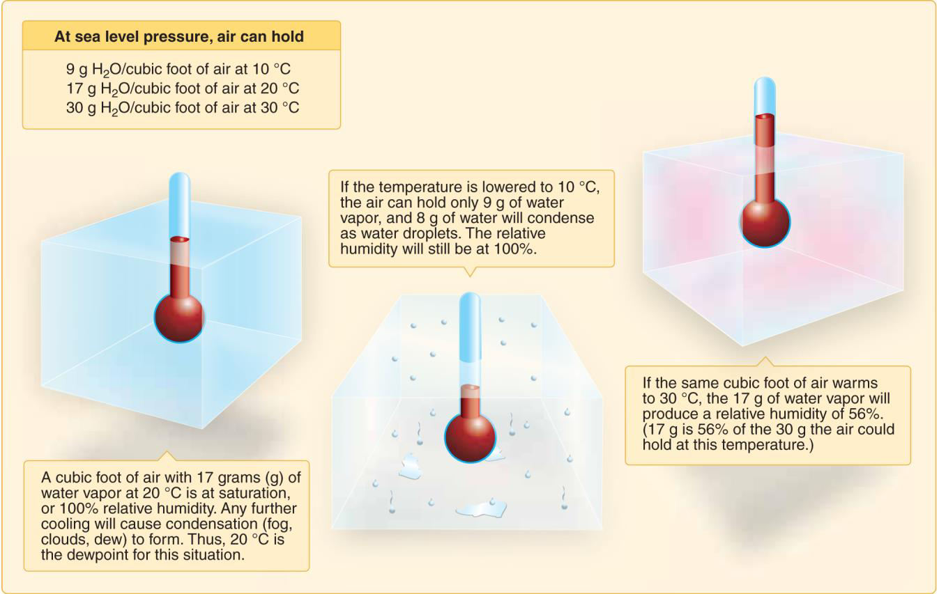
“Fog is more likely to form when the temperature and dew point convergence. A difference between these two temperatures of 3 degrees C (or 5 degrees F) is indicative of possible fog formation. Reference: AC 00-6”
4. C
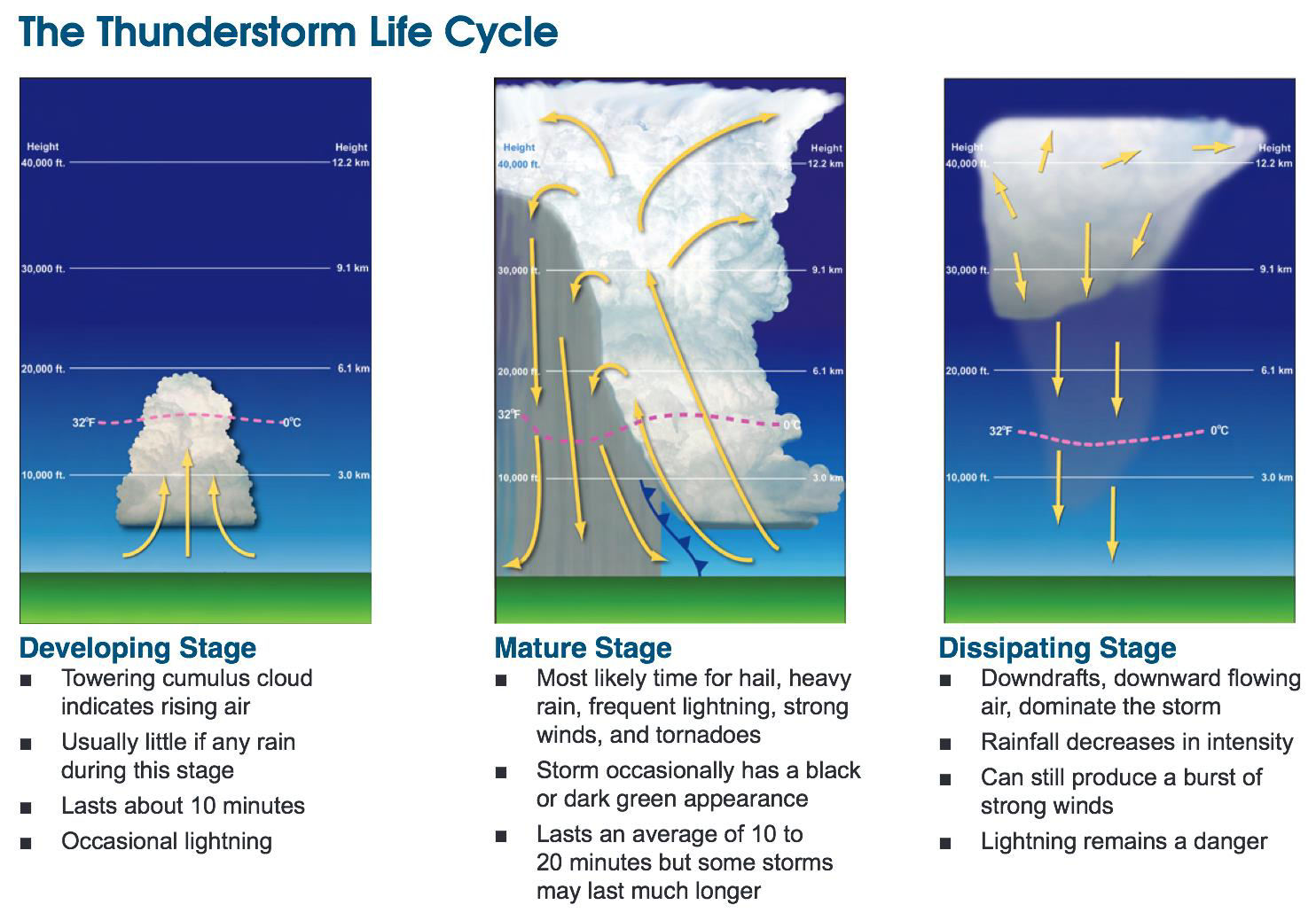
“A thunderstorm is, in general, a local storm invariably produced by a cumulonimbus cloud, and is always accompanied by lightning and thunder. Reference: AC 00-6”
5. C
“The propeller produces thrust in proportion to the mass of air being accelerated through the rotating blades. If the air is less dense, propeller efficiency is decreased. Reference: FAA-H-8083-25”
6. A
“Characteristics of a moist unstable air mass include cumuliform clouds, showery precipitation, rough air (turbulence), and good visibility (except in blowing obstructions) Reference: AC 00-6”
7. B
“A condition favorable for rapid accumulation of clear icing is freezing rain below a frontal surface. Reference: AC 00-6”
8. A
“Wind direction always changes across a front
Reference: AC 00-6”
9. B
“Characteristics of a stable air mass include stratiform clouds and fog, continuous precipitation, smooth air, and fair to poor visibility in haze and smoke.
Reference: FAA-H-8083-25”
10. C
“An individual microburst will seldom last longer than 15 minutes from the time it strikes the ground until dissipation. However, there may be multiple microbursts in the area. Reference: AIM 7-1-25”
11. A
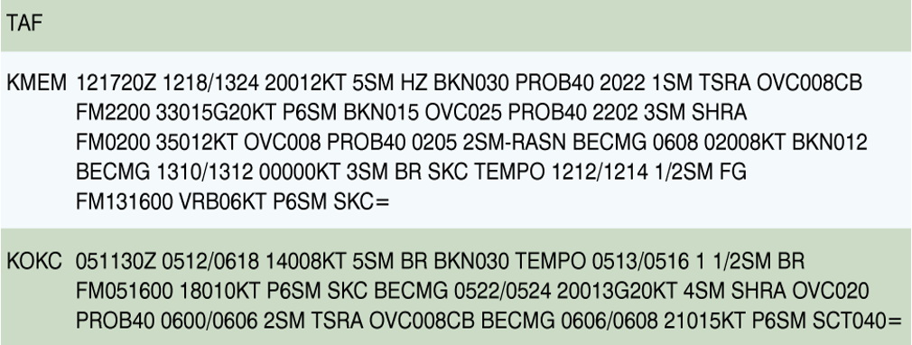
“Between 1000Z and 1200Z, the visibility at KMEM is forecast to be 3 statute miles (BECMG 1012… 3SM)
Reference: AC 00-45”
12. C
“SH” stands for showers and “RA” stands for rain.
Reference: AC 00-45″
13. C
“Crewmembers must operate sUAS Part 107 operations with a minimum visibility, as observed from the location of the control station, no less than 3 statute miles.
Reference: 14 CFR 107.51”
14. B
“From 1600Z until the end of the forecast, wind will be variable in direction at 6 knots (VRB06KT) Reference: AC 00-45”
15. A
“The difference between the existing lapse rate of a given mass of air and the adiabatic rates of cooling in upward moving air determines if the air is stable or unstable. Reference: AC 00-6”
16. B
“On a hot day, the air becomes “”thinner”” or lighter, and its density is equivalent to a higher altitude in the standard atmosphere, thus the term “”high density altitude”” Reference: AC 00-6″
17. B
“Steam fog forms in the winter when cold, dry air passes from land areas over comparatively warm ocean waters. Low level turbulence can occur and icing can become hazardous in a steam fog. Reference: AC 00-6”
18. A
“The wind is reported as a five digit group (six digits if speed is over 99 knots). The first three digits is the direction the wind is blowing from rounded to the nearest tens of degrees relative to true (not magnetic) north, or “”VRB”” if the direction is variable. The next two digits is the speed in knots or if over 99 knots, the next three digits. If the wind is gusty, it is reported as a “”G”” after the speed followed by the highest gust reported. The abbreviation “”KT”” is appended to denote the use of knots for wind speed. The wind group for KJFK is 18004KT which means the wind from 180 degrees at 4 knots. Reference: AC 00-45″
19. B
“Downdrafts characterize the dissipating stage of the thunderstorm cell and the storm dies rapidly. Reference: AC 00-6”
20. A
“Unmanned aircraft often have limited performance and therefore in high wind conditions, it may consume more power to maintain position or other maneuvers than in calm air. If the wind is strong enough, the sUAS’s performance might not be able to adequately counter the wind, making it impossible to fly back to you for recovery.
Reference: FAA-H-8083-25, 14 CFR Part 107.49”
21. C
“Conditions favorable for radiation fog are clear sky, little or no wind, and small temperature/ dew point spread (high relative humidity). Radiation fog is restricted to land because water surfaces cool little from nighttime radiation.
Reference: AC 00-6”
22. A
“All altimeter settings are corrected to sea level, unequal heating of the Earth’s surface causes pressure differences.
Reference: AC 00-6”
23. C
“A squall line is a non-frontal, narrow band of active thunderstorms. The line may be too long to easily detour and too wide and severe to penetrate. It often contains severe steady state thunderstorms and presents the single, most intense weather hazard to aircraft Reference: AC 00-6”
24. A
“For a cumulonimbus cloud or thunderstorm to form the air must have:
1. Sufficient water vapor
2. An unstable lapse rate
3. An initial upward boost (lifting) to start the storm process in motion Reference: AC 00-6”
25. B
“The key feature of the cumulus stage is an updraft. Precipitation beginning to fall from the cloudbase is the signal that a downdraft has developed also and a cell has entered the mature stage. Reference: AC 00-6”
26. C
“Weather factors can greatly influence sUAS performance and safety of flight Reference: AC 107-2”
27. C
“Advection fog forms when moist air moves over colder ground or water. It is most common along coastal areas, but often develops deep in continental areas. Advection fog deepens as wind speed increases up to about 15 knots. Wind much stronger than 15 knots lifts the fog into a layer of low stratus or stratocumulus. Upslope fog forms as a result of moist, stable air being cooked adiabatically as it moves up sloping terrain. Once upslope wind ceases, the fog dissipates. Reference: AC 00-6”
28. A
“All thunderstorms hazards reach their greatest intensity during the mature stage. Reference: AC 00-6”
29. A
“A squall line is a non-frontal, narrow band of active thunderstorms. The line may be too long to easily detour and too wide and severe to penetrate. It often contains severe steady state thunderstorms and presents the single, most intense weather hazard to aircraft Reference: AC 00-6”
30. B
“Two conditions are necessary for structural icing in flight
1. The aircraft must be flying through visible water such as rain or cloud droplets, and
2. the temperature at the point where the moisture strikes the aircraft must be 0 degrees C (32 degrees F) or colder. Reference: AC 00-6”
31. A
“If the temperature is above standard the density altitude will be higher than pressure altitude. Reference: FAA-H-8083-25”
32. C
“Unstable conditions are characterized by cumulus clouds, turbulence, showery precipitations and good visibility.
Reference: AC 00-6”
33. A
“Dry areas get hotter than moist area. Dry fields or dry ground of any nature are better thermal sources than mist areas. This applies to woods or forests, which are poor sources of thermals because of the large amount of moisture given off by foliage. Reference: AC 00-6”
34. A
“Between 2000Z and 2200Z there is a 40% probability (PROB) that is the visibility will drop to 1 SM due to a thunderstorm (TS) and moderate rain (RA). Reference: AC 00-6”
35. C
“Thermals are updrafts in convective currents dependent on solar heating. A temperature inversion would result in stable air with very little, if any, convective activity. Reference: AC 00-6”
36. B
“Characteristics of a stable air mass include stratiform clouds and fog, continuous precipitation, smooth air, and fair to poor visibility in haze and smoke. Reference: FAA-H-8083-25”
37. B
“Local condition, geological features, and other anomalies can change the wind direction and speed close to the Earth’s surface, making it difficult to control and maneuver the sUAS. Reference: FAA-H-8083-25”
38. A
“Advection fog forms when moist air moves over colder ground or water. It is most common along coastal areas. The fog frequently forms offshore as a result of cold water, then is carried inland by the wind.
Reference: AC 00-6”
39. B
“Advection fog forms when moist air moves over colder ground or water. It is most common along coastal areas. The fog frequently forms offshore as a result of cold water, then is carried inland by the wind.
Reference: AC 00-6”
40. A
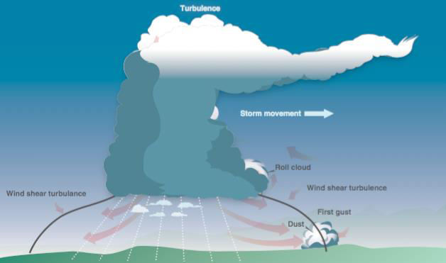
“Wind shear is an invisible hazard associated with all thunderstorms. Shear turbulence has been encountered 20 miles laterally from a severe storm.
Reference: AC 00-6”
41. C
“The key feature of the cumulus stage is an updraft. Precipitation beginning to fall from the cloud base is the signal that a downdraft has developed also and a cell has entered the mature stage. Reference: AC 00-6”
42. C
“Standard sea level pressure is 29.92 inches of mercury, standard sea level temperatures is 15 degree C.
Reference: FAA-H-8083-25”
43. A
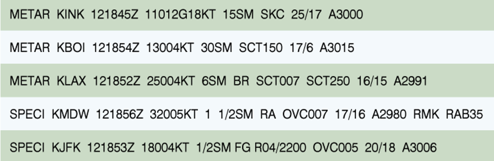
“The current conditions at KMDW are 1-1/2 SM visibility (1-1/2 SM) with rain (RA), ceiling overcast at 700 feet (OVC007)
Reference: AC 00-6”
44. B
“You should request a standard briefing any time you are planning a flight and you have not received a previous briefing.
Reference: FAA-H-8083-25”
45. A
“When air near the surface is warm and moist, suspect instability. Surface heating, cooling aloft, converging or upslope winds, or an invading mass of colder air may lead to instability and cumuliform clouds
Reference: AC 00-6”
46. A
“Temperature is one of the most easily recognized discontinuities across a front Reference: AC 00-6”
47. B
“ASOS is designed to support aviation operations and weather forecast activities. The ASOS will provide continuous minute-by-minute observations and perform the basic observing functions necessary to generate an aviation routine weather report (METAR) and other aviation weather information.
Reference: AIM 7-1-11”
48. B
“A lightning strike can puncture the skin of an aircraft, damage communication and navigation equipment, or hit the remote pilot or crew on the ground.
Reference: AC 00-6”
49. C
“A combination of high temperature, high humidity, and high altitude result in a density altitude higher than the pressure altitude which in turn, results in reduced aircraft performance. Reference: FAA-H-8083-25”
50. A
“Thunderstorms and heavy rain are common, although not always, associated with cold fronts. Reference: AC 00-6”
51. C
“Every physical process of weather is accompanied by, or is the result of, unequal heating of the Earth’s surface
Reference: AC 00-6”
52. A
“Thunderstorm hazards reach their greatest intensity during the mature stage, which is when precipitation begins.
Reference: AC 00-6”
53. A
“Part 107 require the minimum distance of the sUAS from clouds must be no less than 500 feet below the cloud. The towers depicted 4 NM east of K36 are 292 feet AGL. 292 + 500 = 792 feet AGL. Reference: 14 CFR 107.51”
54. B
“A squall line is a nonfrontal, narrow band of active thunderstorms. The line may be too long to easily detour and too wide and severe to penetrate. It often contains severe steady-state thunderstorms and presents the single, most intense weather hazard to aircraft.
Reference: AC 00-6”
55. C
“Regardless of the location, crewmembers must conduct sUAS Part 107 operations with a minimum visibility, as observed from the location of the control station, no less than 3 statute miles. Reference: 14 CFR 107.51”
56. C
“A continuous line of thunderstorms, or squall line, may form along or ahead of the front. Squall lines present a serious hazard to pilots as squall type thunderstorms are intense and move quickly. Squalls can occur at any altitude – they are not unique to high- or low-altitude operations. Reference: AC 00-6”
57. A
“Any convective SIGMET implies severe or greater turbulence, severe icing, and low-level wind shear.
The forecast may be issued for any of the following; severe thunderstorms due to:
1. Surface winds greater than or equal to 50 knots, or
2. Hail at the surface greater than or equal to 3/4 inch in diameter, or
3. Tornadoes, embedded thunderstorms, lines of thunderstorms.
Reference: AC 00-45”
58. C
“An increase in air temperature or humidity, or a decrease in air pressure (which results in a higher density altitude) will significantly decrease both power output and propeller efficiency. If an air mass is humid, there is more water in it, therefore, less oxygen. Reference: AC 00-6”
59. A
“As water vapor condenses or sublimates on condensation nuclei, liquid or ice particles begin to grow. Some condensation nuclei have an affinity for water and can induce condensation or sublimation even when air is almost, but not completely, saturated. Answer (B) is incorrect because the presence of water vapor does not result in clouds, fog, or dew unless condensation occurs. Answer (C) is incorrect because it is possible to have 100% humidity without the occurrence of condensation, which is necessary for clouds, fog, or dew to form. Reference: AC 00-6”
60. B
“The combination of moisture and temperature determine the stability of the air and the resulting weather. Cool, dry air is very stable and resists vertical movement, which leads to good and generally clear weather. Reference: AC 00-6”
61. B
“Part 107 require the minimum distance of the sUAS from clouds must be no less than 500 feet below the cloud. The towers depicted 8 NM SW of CRP are 1,104 feet MSL. 1,104 + 500 = 1,604 feet MSL. Reference: 14 CFR 107.51”
62. A
“When the temperature of the air rises with altitude, a temperature inversion exists. Inversion layers are commonly shallow layers of smooth, stable air close to the ground. The temperature of the air increases with altitude to a certain point, which is the top of the inversion. The air at the top of the layer acts as a lid, keeping weather and pollutants trapped below. If the relative humidity of the air is high, it can contribute to the formation of clouds, fog, haze, or smoke resulting in diminished visibility in the inversion layer.
Reference: AC 00-6”
63. B
“The entry RAB35 means that rain began 35 minutes past the hour. Answer (A) is incorrect because mist is reported as BR. Answer (C) is incorrect because there is no format for reporting an altimeter change in a METAR. Reference: AC 00-45”
64. A
“Wind shear is a sudden, drastic change in wind speed and/or direction over a very small area. Wind shear can subject an aircraft to violent updrafts and downdrafts, as well as abrupt changes to the horizontal movement of the aircraft. While wind shear can occur at any altitude, low-level wind shear is especially hazardous due to the proximity of an aircraft to the ground. Reference: AC 00-6”
65. B
“On cool, clear, calm nights, the temperature of the ground and objects on the surface can cause temperatures of the surrounding air to drop below the dew point. When this occurs, the moisture in the air condenses and deposits itself on the ground, buildings, and other objects like cars and aircraft. This moisture is known as dew and sometimes can be seen on grass and other objects in the morning. If the temperature is below freezing, the moisture is deposited in the form of frost. Reference: AC 00-6”
66. C
“Part 107 require the minimum distance of the sUAS from clouds must be no less than 500 feet below the cloud. 800 cloud – 500 = 300 feet AGL.
Reference: 14 CFR 107.51”
67. A
“The zone between two different air masses is a frontal zone or front. Across this zone, temperature, humidity and wind often change rapidly over short distances.
Reference: AC 00-6”
Loading & Performance (Section 4)
Loading & Performance (Section 4)
1. A
“Any mounted equipment should be balanced in a manner that does not adversely affect the center of gravity or result in unsafe performance. Reference: AC 107-2”
2. A
“Loading the aircraft outside of limitations (weight, balance, or both) may lead to moments that exceed the capabilities of the flight controls/ engine (s), thus possibly leading to loss of control or other performance anomalies Reference: FAA-H8083-1”
3. B
“The airfoil will stall if the critical angle of attach is exceeded.
Reference: FAA-H-8083-3”
4. B
“The maximum endurance condition is obtained at the point of minimum power required since this would require the lowest fuel flow or battery to keep the sUAS in steady, level flight. Maximum range condition occurs where the proportion between speed and power required is greatest. Reference: FAA-H-8083-25”
5. A
“Total range is dependent on both fuel available and specific range. When range and economy of operation are the principal goals, the remote pilot must ensure that the sUAS is operated at the recommended long range cruise condition. By this procedure, the sUAS will be capable of its maximum design-operating radius, or can achieve lesser flight distances with a maximum of fuel reserve at the destination
Reference: FAA-H-8083-25”
6. C
“The manufacturer is the best source of performance data and information, if available Reference: FAA-H-8083-25”
7. B
“Refer to Figure 2 and use the following steps
1. Enter the chart at a 60 degree angle of bank and proceed upward to the curved reference line.
2. From the point of intersection, move to the left side of the chart and read a load factor of 2Gs.
3. Multiply the aircraft weight by the load factor: 10×2=20 lbs or working from the table 10×2.0 (load factor) = 20 lbs
Reference: FAA-H-8083-25”
8. A
“The effect of runway slope on launch distance is due to the component of weight along the inclined path of the aircraft. An upslope would contribute an accelerating force component. In the case of an upslope, the retarding force component adds to drag and rolling friction to reduce the net accelerating force.
Reference: FAA-H-8083-25”
9. C
“Unmanned airplane performance can be decreased due to an increase in load factor when the airplane is operated in maneuvers other than straight and level flight. Reference: FAA-H-8083-25”
10. C
“The most critical conditions of launch performance are the result of some combination of high gross weight, altitude, temperature and unfavorable wind. In all cases the remote pilot must make and accurate prediction of take-off distance from the performance data of the AFM/ POH, regardless of the runway available, and strive for polished, professional launch procedures. Reference: FAA-H-8083-25”
11. A
“Prior to each flight, the remote PIC must ensure that any object attached to or carried by the small unmanned aircraft is secure and does not adversely affect the flight characteristics or controllability of the aircraft
Reference: AC 107-2”
12. B
“Stall speed increases in proportion to the square root of the load factor. Thus, with a load factor of 4, an aircraft will stall, at a speed which is double the normal stall speed. Reference: FAA-H-8083-25”
13. C
“To determine altitude, with the sUAS on the ground, the remote pilot and VO should pace off 400 feet from the sUAS to get a visual perspective of the sUAS at that distance, wherein the remote pilot and VO maintain that visual perspective or closer while the sUAS is in flight Reference: AC 107-2”
14. A
“Referencing Appendix 1, Figure 2, use the following steps:
1.Enter the chart at a 30 degree angle of bank and proceed upward to the curved reference line. From the point of intersection, move to the left side of the chart and read an approximate load factor of 1.2 Gs.
2.Multiply the aircraft weight by the load factor: 33*1.2=39.6 lbs Or, working from the table:33*1.154 (load factor)= 38.1 lbs.
Reference: FAA-H-8083-25”
15. B
“when the angle of attack is increased to between 18 and 20 degrees (critical angle of attack) on most airfoils the airstream can no longer follow the upper curvature of the wing because of the excessive change in direction. The airfoil will stall if the critical angle of attack is exceeded. The airspeed at which stall occurs will be determined by weight and load factor, but the stall angle of attack is the same. Reference: FAA-H-8083-25”
16. A
“Without a GPS or manufacturer performance data, you can determine speed of the sUAS when it is flown between two or more fixed points, taking into account wind speed and direction between each point, then noting the power settings of the sUAS to operate at or less than 87 knots ground speed. This is a form of dead reckoning.
Reference: FAA-H-8083-25,AC 107-2”
17. B
“At slow speeds, the maximum available lifting force of the wing is only slightly greater than the amount necessary to support the weight of the sUAS. However, at high speeds, the capacity of the flight
controls or a strong gust, may increase the load factor beyond safe limits, Reference: FAA-H-8083-25”
18. A
“The angle of attack is the acute angle between the relative wind and the chord line of the wing. Reference: FAA-H-8083-25”
19. C
“Excessive weight reduces the flight performance in almost every respect, including a shorter endurance. In addition, operating above the maximum weight limitation can compromise the structural integrity of an unmanned aircraft. Reference: AC 107-2”
20. C
“In addition to local resources, the sectional chart for that region should be consulted for information or the altitude of the terrain and structures. towers and other known obstructions are depicted with their altitude noted.
Reference: Sectional chart”
21. A
“Use the following steps:
1.Enter the chart at a 30 degree angle of bank and proceed upward to the curved reference line. From the point of intersection, move to the left side of the chart and read an approximate load factor of 1.2 Gs.
2.Multiply the aircraft weight by the load factor: 50*1.2= 60 lbs Or, working from the table:
50*1.154 (load factor)= 57.7 lbs.
Reference: FAA-H-8083-25”
22. B
“A change in speed during straight flight will not produce any appreciable change in load but when a change is made in the sUAS flight path, an additional load is imposed upon the structure. This is particularly true if a change in direction is made at high speeds with rapid, forceful control movements. Reference: FAA-H-8083-25”
23. A
“Before any flight, verify that the unmanned aircraft is correctly loaded by determining the weight and balance condition. Review any available manufacturer weight and balance data and follow all restrictions and limitations.
Reference: FAA-H-8083-1”
24. C
“It is the responsibility of the remote PIC to use the most current weight and balance data when planning a flight and operating the sUAS. Reference: FAA-H-8083-1”
25. B
“The remote PIC is responsible for ensuring that every flight can be accomplished safely, does not pose an undue hazard, and does not increase the likelihood of a loss of positive control. Reference: 14 CFR 107.12”
26. A
“The purpose of the rudder is to control yaw. Answer (B) is incorrect because the ailerons control bank. Answer (C) is incorrect because pitch is controlled by the elevator. Reference: FAA-H-8083-25”
27. A
“In addition to local resources, the sectional chart for that region should be consulted for information on the altitude of the terrain and structures. Towers and other known obstructions are depicted with their altitude noted.
Reference: Sectional Chart”
28. B
“Stall speed increases in proportion to the square root of the load factor. Thus, with a load factor of 4, an aircraft will stall at a speed which is double the normal stall speed. Reference: FAA-H-8083-25”
29. A
“Operation with the center of gravity (CG) outside the approved limits results in control difficulty.” Reference: FAA-H-8083-25
Operations (Section 5)
1. A
“A flyaway is when the sUAS becomes uncontrollable and does not operate in a manner that would be expected in a normal or lost link flight situation.
Reference: 14 CFR Part 107”
2. C
“Fatigue can be either acute (short-term) or chronic (long-term). Acute fatigue, a normal occurrence of everyday living, is the tiredness felt after long periods of physical and mental strain, including strenuous muscular effort, immobility, heavy mental workload, strong emotional pressure, monotony, and lack of sleep. Chronic fatigue occurs when there is not enough time for a full recovery from repeated episodes of acute fatigue.
Reference: FAA-H-8083-25”
3. A
“Frequency interference is one of the most common causes of flyaways; therefore, remote PICs should assess the risk of such interference prior to and during flight. Extra caution is necessary when operating in the vicinity of other sUAS. The loss of GPS may degrade the sUAS capabilities slightly but should not cause a flyaway. It is not unusual for people to stand near the control station; it is highly unlikely for this to cause a flyaway. Reference: AC 107-2”
4. C
“An aircraft exiting a runway is not clear of the runway until all parts of the aircraft have crossed the applicable holding position marking. Reference: AIM 2-3-5”
5. C
“The preferred source of information is the manufacturer’s guidance about maintenance schedule and instructions,
Reference: AC 107-2”
6. B
“Remote PICs should monitor the appropriate aviation frequency such as CTAF during flight operations and make announcement concerning sUAS operations as appropriate. Some sUAS require the use of cellphone or tablet computers for operation, therefore are acceptable for use in most cases. The best way to avoid frequency interference is to check local frequency spectrum use prior to flight and continue to monitor such use during flight by utilizing a frequency spectrum analyzer. Reference: AC 107-2”
7. A
“Follow all manufacturer maintenance recommendations to achieve the longest safest service life of the sUAS. if the sUAS or component manufacturer does not provide scheduled maintenance instructions, it is recommended that you establish your own scheduled maintenance protocol. Reference: AC 107-2”
8. B
“The remote PIC is responsible for determining whether that aircraft is in condition for safe flight. Reference: FAA-H-8083-25”
9. B
“Hyperventilation is most likely to occur during period of stress or anxiety Reference: AIM 8-1-3”
10. C
“Most sUAS are designed to fly normally with minimal impact on features or controllability if GPS signals are degraded or lost. Loss of GPS is not an emergency and is not considered to be a loss of link between the unmanned aircraft and the control station. If the failure of GPS does result in a flyaway or other dangerous situation, it should be treated as an emergency. Reference: AC 107-2”
11. A
“A pilot who has just landed should not change from the tower frequency to the ground control frequency until directed to do so by the controller Reference: AIM 4-3-14”
12. B
“Most sUAS are designed to fly normally with minimal impact on features or controllability if GPS signals are degraded or lost. Loss of GPS is not an emergency and is not considered to be a loss of link between the unmanned aircraft and the control station. If the failure of GPS does result in a flyaway or other dangerous situation, it should be treated as an emergency. Reference: AC 107-2”
13. A
“Pilot performance can be seriously degraded by both prescribed and over-the-counter medications, as well as by the medical conditions for which they are taken. Flying is almost always precluded while using prescription analgesics since these drugs may cause side effects such as mental confusion, dizziness, headaches, nausea, and vision problems. Depressants, including antihistamines, lower blood pressure, reduce mental processing and slow motor and reaction responses. Reference: FAA-H-8083-25”
14. C
“The antiauthority (don’t tell me) attitude is found in people who do not like anyone telling them what to do. The antidote for this attitude is: follow the rules, they are usually right. Reference: FAA-H-8083-25”
15. A
“Damaged batteries should never be used or charged. Lithium batteries do normally get warm during discharge. Avoid the use of hot batteries. New batteries should be treated per manufacturing instructions, but do not normally need several charge cycles to use.
Reference: SAFO 10017”
16. B
“No person may operate a sUAS unless it is in a condition for safe operation. Prior to each flight, the remote pilot-in-command must check the sUAS to determine whether it is in a condition for safe operation. No person may continue flight of the small unmanned aircraft when he or she knows or has reason to know that the small unmanned aircraft system is no longer in a condition for safe operation Reference: 14 CFR 107.15”
17. B
“The term “”initial radio contact”” or “”initial call-up”” means the first radio call you make to a given facility, or the first call to a different controller or Flight Service specialist within a facility.
Use the following format:
1. Name of the facility being called
2. You full aircraft identification as filed in the flight plan
3. Type of message to follow or your request if it is short
4. The word “”over”” if required (typically omitted, except for communications via a remote communication outlet or in cases when it is necessary to confirm the end of a transmission
Example: New York Radio, Mooney Three One One Echo, over
When the aircrafts manufacturer’s name or model is stated, the prefix “”N”” is dropped. The first two characters of the call sign may be dropped only after ATC calls you by your last three numbers
Reference: AIM 4-2-3″
18. C
“The pilot is responsible for determining whether he or she is fit to fly for a particular flight Reference: FAA-H-8083-25”
19. A
“The fatigues pilot is an impaired pilot, and flying requires unimpaired judgement Reference: FAA-H-8083-2”
20. A
“During a flyaway event sUAS may not react in ways that can be expected or predicted thus this is an emergency situation. The remote PIC should immediately communicate this emergency to crewmembers and ATC (if applicable) as well as any persons in the immediate area so as to minimize risk for injury. There is no obligation to contact the NTSB or law enforcement during a flyaway. Reference: 14 CFR 107.19, 107.21”
21. B
“The preflight inspection should be a thorough and systematic means by which the remote PIC determines that the sUAS is ready for safe flight. Most aircraft flight manuals or Pilot’s operating handbooks contain a section on preflight inspection that should be used for guidance in this Reference: FAA-H-8083-25”
22. A
“The remote PIC must inspect the sUAS before each flight
Reference: 14 CFR 107.49”
23. C
“All participants in the sUAS operation and ATC (if operating within or near controlled airspace) should be notified of the lost link situation, an emergency should be declared. There is no obligation to contact law enforcement. It is never recommended to turn off the control station when the UA engines are running or if it is in flight.
Reference: AC 107-2, 14 CFR 107.21”
24. A
“MULTICOM frequency is always 122.9 MHz and the correct procedure is to broadcast intentions when 10 miles from the airport
Reference: AIM 4-1-9”
25. B
“When there is no tower, Flight service, or UNICOM station on the airport use MULTICOM frequency 122.9 for self-announce procedures. Such airports will be identified in the appropriate aeronautical information publications. Reference: AIM 4-1-9”
26. A
“To avoid missing important steps, always use the appropriate checklists whenever, they are available. Consistent adherence to approved checklists is a sign if a disciplined and competent pilot. Reference: FAA-H-8083-25”
27. C
“Impulsivity, as a hazardous attitude, has the motto “”Do it quickly”” The person frequently feels the need to do something, anything, immediately. He or she does not stop to think about the best alternative and does the first thing that comes to mind. Reference: FAA-H-8083-25″
28. B
“Up to but not including 18,000 feet MSL, state the separate digits of the thousands, plus the hundreds, if appropriate. Example: “”4,500-four thousand, five hundred”” Reference: AIM 4-2-9″
29. B
“The absence of a sky condition or ceiling and/or visibility on ATIS indicates a ceiling of 5,000 feet or above and visibility of 5 miles or more. Reference: AIM 4-1-13”
30. A
“Risk management is the part of the decision making process that relies on situational awareness, problem recognition, and good judgement to reduce the risks associated with each flight. Reference: FAA-H-8083-25”
31. C
“Where there is no tower or UNICOM station on the airport, use MULTICOM frequency 122.9 for selfannounce procedures. Reference: AIM 4-1-9”
32. A
“An abnormal increase in the volume of air breathed in and out of the lungs flushes an excessive
amount of carbon dioxide from the lings and blood, causing hyperventilation Reference: AIM 8-1-3”
33. B
“A culture of safety must be established with all commercial sUAS operations. This safety culture may use a number of techniques including situational awareness, risk based aeronautical decision making
(ADM) crew resource management (CRM) and safety management systems(SMS) Reference: FAA-H-8083-25”
34. C
“Pilots of inbound traffic should monitor and communicate as appropriate on the designated CTAF from 10 miles to landing. Pilots of departing aircraft should monitor/ communicate on the appropriate frequency from start-up, during taxi and until 10 miles from the airport unless the regulations or local procedures require otherwise. Refere1nce: AIM 4-1-9”
35. C
“ATIS is the continuous broadcast of recorded non-control information in selected high activity terminal areas
Reference: AIM 4-1-13”
36. A
“The remote PIC must inspect the sUAS before each flight
Reference: 14 CFR 107.49”
37. B
“Follow all manufacturer maintenance recommendations to achieve the longest safest service life of the sUAS. By abiding by the more restrictive limitation or component life cycle the remote PIC will be
assured of being in compliance of both the sUAS and battery manufactures’ guidelines Reference: AC 107-2”
38. A
“Traffic information will be given in azimuth from the aircraft in terms of the 12 hour clock. Thus each hour would constitute an angle of 30 degrees. If an aircraft is proceeding on a heading of 090 degrees (east) traffic located at 3’o clock position would be 90 degrees right of the nose, south of the aircraft. If the sUAS is being operated to the south of the aircraft, the aircraft itself is to the north of the operation. Reference: AIM 4-1-15”
39. B
“An aircraft flying north in calm wind would be heading 360 degrees. When advised of traffic at the 9’O clock position, the pilot should look 90 degrees left of the nose, to the west but the Remote PIC and
sUAS need to look to the east as they are to the west of the manned aircraft Reference: AIM 4-1-15”
40. C
“Crewmembers should express any and all concerns about decisions of the remote PIC or other crewmembers at any time. Clearly, the remote PIC is in charge, but that doesn’t not always make them right or invulnerable to errors, omissions, or other potentially hazardous instances Reference: FAA-H-8083-25”
41. C
“if the operation is to take place in the afternoon, the sun will be setting towards the west and could impair the vision of those participating in the sUAS operation. Thus, when practical, the operation should be set up to minimize the impact of the the sun on being able to maintain the visual line of sight with the unmanned aircraft
Reference: FAA-H-8083-25, 14 CFR 107.31”
42. A
“Risk management is the part of the decision making process that relies on situational awareness, problem recognition, and good judgement to reduce the risks associated with each flight. Reference: FAA-H-8083-25”
43. B
“Both lithium metal and lithium -ion batteries are highly flammable and capable of self-ignition when a battery short circuits or is overcharged, heated to extreme temperature, mishandled or otherwise defective
Reference: SAFO 10017”
44. A
“Machoism, as a hazardous attitude, has the motto “”I can do it, I’ll show them”” The person tries to prove that he or she is better than anyone else. the person takes risks to impress others. Reference: FAA-H-8083-25″
45. C
“If the operation is to take place in snow covered environment, awareness concerning how this may impact vision, such as a glare or the ability to see and operate the unmanned aircrafts against a featureless background. Thus, when practical, the operation should be set up to minimize the impact of
the the sun on being able to maintain the visual line of sight with the unmanned aircraft Reference: FAA-H-8083-25, 14 CFR 107.31”
46. A
“As a pilot, flying for long periods in hot summer temperatures or at high altitudes increases the susceptibility of dehydration since the dry air at altitude tends to increase the rate of water loss from the body. If this fluid is not replaced, fatigue progresses to dizziness, weakness, nausea, tingling of hands and feet, abdominal cramps, and extreme thirst. Reference: FAA-H-8083-25”
47. B
“Follow all manufacturer maintenance recommendations to achieve the longest and safest service life of the sUAS. If the sUAS or component manufacturer does not provide scheduled maintenance instructions, it is recommended that you establish your own scheduled maintenance protocol. Reference: AC 107-2”
48. B
“Crew resource management is the effective use of all available resources – human, hardware and information – prior to and during flight to ensure a successful outcome of the operation. The remote PIC must integrate crew resource management techniques into all phases of the sUAS operation. Reference: FAA-H-8083-25”
49. A
Acute fatigue is short term and is normal occurrence in everyday living. It is the kind of tiredness people feel after a period of strenuous effort, excitement, or lack of sleep.
50. C
“ADM addresses the following five hazardous attitudes. antiauthority (don’t tell me) impulsivity (do something quickly) invulnerability (it won’t happen to me) machoism (I can do it) resignation (what’s the use)
Reference: FAA-H-8083-25”
51. A
“Pilots should state their position on the airport, when calling the tower for takeoff from a runway intersection
Reference: AIM 4-3-10”
52. B
“When in doubt, remove and replace any damaged part. If repair is allowed, it should be outlines by the manufacturer. Remote PICs should consult with the manufacturer about such repair. Reference: AC 107-2”
53. A
“using standard phraseology, remote PICs/ crew should clearly communicate the position of the sUAS operation in relation to a known geographic location and any other information that may help the manned aircraft be aware of and avoid conflicting with the sUAS
Reference: AIM 4-1-15, AC 107-2”
54. C
“Flight Service Stations (FSS’s) are air traffic facilities that provide pilot briefings, enroute communications and VFR search-and-rescue services, assist lost aircraft and aircraft in emergency situations, relay ATC clearances, originate notice to Airmen, broadcast aviation weather and NAS information, receive and process IFR flight plans, and monitor NAVAIDs. In addition, FSS’s take weather observations, issue airport advisories, advise customs and immigration of transborder flights, and provide En route flight advisory service (Flight watch) (in Alaska only) Reference: AIM 4-1-3”
55. B
“Crew resource management is the effective use of all available resources – human, hardware and information – prior to and during flight to ensure a successful outcome of the operation. Reference: AC 107-2”
56. A
“Fatigue is one of the most treacherous hazards to flight safety as it may not be apparent to a pilot until serious errors are made” Reference: FAA-H-8083-25”
57. B
“Getting behind the aircraft” or falling can result in not knowing where you are, an inability to recognize
deteriorating circumstances, and/or the misjudgment of the rate of deterioration Reference: FAA-H-8083-25″
58. B
“Your first action should be to seek out the manufacturer’s guidance about replacement or disposal. Do not use damaged batteries, as they may self-ignite during flight or if charged. Reference: AC 107-2”
59. A
“CTAF is designed for the purpose of carrying out airport advisory practices and/or position reporting at an uncontrolled airport (which may also occur during hours when a tower is closed). The CTAF may be a UNICOM, MULTICOM, FSS, or tower frequency and is identified in the appropriate aeronautical publications. On the sectional chart, a solid dot with the letter “C” inside indicates Common Traffic Advisory Frequency. When the control tower operates part time and a UNICOM frequency is provided, use the UNICOM frequency.
Reference: AIM 4-1-9”
60. C
“CTAF is a frequency designed for the purpose of carrying out airport advisory practices and/or position reporting at an uncontrolled airport (which may also occur during hours when a tower is closed). The CTAF may be a UNICOM, MULTICOM, FSS, or tower frequency and is identified in the appropriate aeronautical publications. A solid dot with the letter “C” inside indicates CTAF. When the control tower operates part time and a UNICOM frequency is provided, use the UNICOM frequency. Reference: AIM 4-1-9”
61. A
“Situational awareness is the accurate perception and understanding of all the factors and conditions within the five fundamental risk elements (flight, pilot, aircraft, environment, and type of operation that comprise any given aviation situation) that affect safety before, during, and after the flight. Reference: FAA-H-8083-25”
62. C
“To fly safely, the pilot needs to assess the degree of risk and determine the best course of action to mitigate the risk.
Reference: FAA-H-8083-25”
63. B
“There are several techniques to help manage the accumulation of life stresses and prevent stress overload. For example, to help reduce stress levels, set aside time for relaxation each day or maintain a program of physical fitness. To prevent stress overload, learn to manage time more effectively to avoid pressures imposed by getting behind schedule and not meeting deadlines. Reference: FAA-H-8083-25”
64. C
“Virtually all medications have the potential for adverse side effects in some people. Reference: FAA-H-8083-25”
65. A
“Aircraft call signs should be spoken in their entirety, using the phonetic alphabet. Numbers are spoken individually.
Reference: AIM 4-2-3”
66. C
Impulsivity (do something quickly!) is the attitude of people who frequently feel the need to do something, anything, immediately. They do not stop to think about what they are about to do, they do not select the best alternative, and they do the first think that comes to mind. The antidote for this attitude is: Not so fast. Think first. (PLT103) – FAA-H-8083-25
SAMPLE TEST
1. A
Category: Regulations
“You may operate an sUAS from a moving vehicle if you are in a sparsely populated area and the driver does not serve as the remote PIC, person manipulating the controls, or visual observer. Reference: 14 CFR 107.25”
2. B
Category: Regulations
“This sUAS operation is subject to 14 CFR Part 107 because the compensation (money or otherwise) makes the operation commercial in nature
Reference: 14 CFR 107.3”
3. B
Category: Regulations
“Each remote PIC who deviates from a rule in Part 107 must, upon request of the FAA administrator, send a written report of that deviation to the Administrator
Reference: 14 CFR 107.21”
4. A
Category: Regulations
“Refer to Appendix 1, Legend 1. The routes established between VORs are depicted by blue-tinted bands showing the airway number following the letter “”V””, and are called “”Victor airways””. Remote pilots should exercise vigilance in looking for other aircraft when operating near these high density areas.
Reference: Sectional Chart Legend.”
5. B
Category: Regulations
“The remote pilot operating an sUAS must yield right-of-way to all other manned aircraft, including aircraft operating on the surface of the aircraft.
Reference: 14 CFR 107.37”
6. A
Category: Regulations
“No report is required because the damage can be repaired for less than $500. A report is required only when damage to any property, other than the small UA, is greater than $500 to repair or replace the property (whichever is lower). The cost of the sUAS is not considered when determining if an event is considered to be an accident or incident.
Reference: 14 CFR 107.9, AC 107-2”
7. B
Category: Regulations
“No person may act as a pilot-in0command (PIC), or in any other capacity as a required pilot flight crewmember when operating a sUAS unless he or she has in possession or readily accessible a current-pilot certificate.
Reference: 14 CFR 107.7”
8. B
Category: Regulations
“The remote pilot application must be submitted to a Flight Standards District Office (FSDO), a designated pilot examiner (DPE), an airman certification representative for a pilot school, a certified flight instructor (CFI), or other person authorized by the Administrator to process the application. Reference: 14 CFR 107.63 and 61.56”
9. A
Category: Regulations
“The remote PIC must report any sUAS accident to the FAA, within 10 days of the operation, if a serious injury to any person or any loss of consciousness occurs. It would be considered a serious injury if a person requires hospitalization.
Reference: 14 CFR 107.9, AC 107-2”
10. C
Category: Regulations
14 CFR Part 107 does not apply to model aircraft that meet the criteria in 14 CFR 101.41, amateur rockets, moored balloons or unmanned free balloons, kites, operations conducted outside the United States, public aircraft operations, and air carrier operations.
11. A
Category: Regulations
“No person may act, or attempt to act, as a crewmember of a civil aircraft while having .04 percent or more, by weight alcohol in the blood.
Reference: 14 CFR 107.27,91.17”
12. A
Category: Regulations
“Although not required by Part 107, the FAA encourages applicants to submit their application at least 90 days prior to the start of the proposed operation. The FAA will strive to complete review and adjudication of waiver within 90 days; however, the time required for the FAA to make a determination regarding waiver requests will vary based on the complexity of the request. Reference: AC 107-2”
13. B
Category: Regulations
“Report any sUAS accident to the FAA within 10 days if it results in serious injury, loss of consciousness, or repairs costing over $500.
Reference: 14 CFR 107.9”
14. A
Category: Regulations
“The sUAS cannot be flown higher than 400 feet AGL unless flown within a 400-foot radius of a structure and is not flown higher than 400 feet above the structure’s immediate upper-most limit. Reference: 14 CFR 107.51”
15. C
Category: Regulations
“No person may manipulate the flight controls of a small unmanned aircraft system or act as a remote pilot-in-command, visual observer, or direct participant in the operation of the small unmanned aircraft if he or she knows or has reason to know that he or she has a physical or mental condition that would interfere with the safe operation of the small un manned aircraft system. Reference: 14 CFR 107.17 ”
16. C
Category: Regulations
“Prior to flight, the remote PIC must ensure that all persons directly participating in the small unmanned aircraft operation are informed about the operating conditions, emergency procedures, contingency procedures, roles and responsibilities, and potential hazards.
Reference: 14 CFR 107.49, AC 107-2”
17. A
Category: Regulations
“This scenario is not compliant with Part 107. Visual aids such as binoculars may be used only momentarily to enhance situational awareness. they may not be used during the duration of the operation.
Reference: 14 CFR 107.31”
18. B
Category: Regulations “The remote PIC is ultimately responsible for assessing the needs of the operation and preparing sufficient support crewmembers to ensure the safety of the operation.
Reference: 14 CFR 107.12”
19. A
Category: National Airspace System
“The chart supplement US includes airport details, including the airspace the airport lies in. Figure 31 shows Coeur D’ Alene airport within Class E airspace.
Reference: Chart Supplement”
20. A
Category: National Airspace System
“Notice to Airmen (NOTAMs provide the most current information available) and can be found by visiting www.faa.org or obtained at a flight service station (FSS). A comprehensive weather briefing can be obtained as part of a standard preflight briefing. Reference: FAA-H-8083-25”
21. B
Category: National Airspace System
“The GXF airport is surrounded by a dashed blue line which indicates it is within Class D airspace. Reference: Sectional Chart”
22. A
Category: National Airspace System
“Taxiway ending markers are used to indicate that the taxiway foes not continue Reference: AIM 2-3-4”
23. C
Category: National Airspace System
“Entries into traffic patterns while descending create specific collision hazards and should be avoided. Reference: AIM 4-4-15”
24. C
Category: National Airspace System
“TFRs are imposed in order to:
1. Protect persons and property in the air or on the surface from an existing or imminent flight associated hazard
2. Provide a safe environment for the operation of disaster relief aircraft
3. Prevent an unsafe congestion of sightseeing aircraft above an incident 4. Protect the President, Vice President, or other public figures, and,
5. Provide a safe environment for space agency operations.
Pilots are expected to check appropriate NOTAMs during flight planning when conducting flight in an area where a TFR is in effect Reference: FAA-H-8083-25”
25. A
Category: National Airspace System
“The taxiway directional sign identifies the designation(s) of the intersecting taxiway(s) leading out of the intersection that a pilot would normally be expected to turn onto or hold short of. Reference: AIM 2-3-10”
26. B
Category: Regulations
“This sUAS operation is subject to 14 CFR part 107 because the aerial imagery is for the furtherance of a business, making it commercial in nature.
Reference: 14 CFR 107.3”
27. A
Category: Regulations
“Each remote PIC who deviates from a rule in Part 107 must, upon request of the FAA administrator, send a written report of that deviation to the Administrator
Reference: 14 CFR 107.21”
28. B
Category: Regulations
“this sUAS operation is not subject to FAA sUAS regulations because the sUAS operation is recreational in nature. Part 101 details the regulations pertinent to model aircraft and hobby operations. Reference: 14 CFR Part 107.3”
29. B
Category: Regulations
“When sUAS operations are conducted during civil twilight, the sUAS must be equipped with anticollision lights that are capable of being visible for at least 3 statute miles. Reference: 14 CFR 107.29”
30. A
Category: Regulations
“Each remote pilot shall, before each flight, assess the operating environment including local weather condition, local airspace and any flight restrictions, the location of persons and property on the surface, and other ground hazards. Reference: 14 CFR 107.49”
31. B
Category: Regulations
“You may not operate a small unmanned aircraft directly over another person unless that person is directly involved in the operation (such as a visual observer or other crewmember) or within a safe cover, such as inside a stationery vehicle or a protective structure that would protect a person from harm if the small unmanned aircraft were to crash into that structure.
Reference: 14 CFR 107.39”
32. A
Category: Regulations
“In case of an in-flight emergency, the remote PIC is permitted to deviate from any rule of Part 107 to the extent necessary to respond to that emergency.
Reference: 14 CFR 107.21”
33. B
Category: Regulations
“The visual observer (when asked by the remote PIC) maintains visual line of sight with sUAS and reports any potential hazards to the remote PIC and person manipulating the controls. Reference: 14 CFR 107.33”
34. A
Category: Regulations
“No person may act as a pilot-in0command (PIC), or in any other capacity as a required pilot flight crewmember when operating a sUAS unless he or she has in possession or readily accessible a current-pilot certificate.
Reference: 14 CFR 107.7”
35. B
Category: Regulations
“A remote pilot-in-command, owner, or person manipulating the flight controls of a small unmanned aircraft must, upon request, make available to the administrator: (1) the remote pilot certificate with a small UAS rating; and (2) any other document, record, or report required. Reference: 14 CFR 107.7”
36. A
Category: Regulations
“The sUAS cannot be flown faster than a ground speed of 87 knots (100mph) and must be operated below 400 feet.
Reference: 14 CFR 107.51”
37. B
Category: Regulations
“Operation of an sUAS is permitted from a moving land or waterborne vehicle over a sparsely populated (or unpopulated) area.
Reference: 14 CFR 107.25”
38. B
Category: National Airspace System
“Cooperstown Airport depicts one runway; RWY 13 means the aircraft will be headed 130 degrees upon landing. “”Left downwind”” means the aircraft is currently to the left side, heading opposite and
midway of the landing runway. This would place the aircraft east of the landing runway Reference: AIM 4-1-5″
39. A
Category: National Airspace System
“The “”98″” north of area 7 is the line of longitude east and west of the line that passes through Greenwich, England.
Reference: FAA-H-8083-25″
40. C
Category: National Airspace System
“TFRs are imposed in order to:
1. Protect persons and property in the air or on the surface from an existing or imminent flight associated hazard
2. Provide a safe environment for the operation of disaster relief aircraft
3. Prevent an unsafe congestion of sightseeing aircraft above an incident 4. Protect the President, Vice President, or other public figures, and,
5. Provide a safe environment for space agency operations.
Pilots are expected to check appropriate NOTAMs during flight planning when conducting flight in an area where a TFR is in effect
Reference: FAA-H-8083-25”
41. A
Category: National Airspace System
“The thick blue lines on the sectional chart indicate the boundaries of the overlying Class B airspace. Within each segment, the floor and ceiling are denoted by one number over a second number or the letters SFC. The floor of the class B airspace is 4,000 feet MSL.
Reference: AIM 13-2-3”
42. B
Category: National Airspace System
“The recommended entry position for an airport traffic pattern is 45 degrees to the midpoint of the downwind left at traffic pattern altitude Reference: AIM 4-3-3”
43. C
Category: National Airspace System
“Runway hold markings are indicated by two double dashed and two solid yellow lines. You are considered to be on the taxiway on the double solid yellow line side while you are considered to be on the runway if on the double dashed yellow line side. Reference: AIM 2-3-4”
44. C
Category: Weather
“Part 107 sUAS operations require the minimum distance of the small unmanned aircraft from clouds must be no less than 500 feet below the cloud and 2,000 feet horizontally from the cloud. Reference: 14 CFR 107.51”
45. B
Category: Weather
“Thermals are updrafts in convective currents dependent on solar heating. A temperature inversion would result in stable air with very little, if any, convective activity. Reference: AC 00-6”
46. A
Category: Weather
“A squall line is a non-frontal, narrow band of active thunderstorms. The line may be too long to easily detour and too wide and severe to penetrate. It often contains severe steady state thunderstorms and presents the single, most intense weather hazard to aircraft Reference: AC 00-6”
47. A
Category: Weather
“Advection fog forms when moist air moves over colder ground or water. It is most common along coastal areas. The fog frequently forms offshore as a result of cold water, then is carried inland by the wind.
Reference: AC 00-6”
48. C
Category: Weather
“On a hot day, the air becomes “”thinner”” or lighter, and its density is equivalent to a higher altitude in the standard atmosphere, thus the term “”high density altitude”” Reference: AC 00-6″
49. C
Category: Weather
“Conditions favorable for radiation fog are clear sky, little or no wind, and small temperature/ dew point spread (high relative humidity). Radiation fog is restricted to land because water surfaces cool little from nighttime radiation. Reference: AC 00-6”
50. C
Category: Weather
“A thunderstorm is, in general, a local storm invariably produced by a cumulonimbus cloud, and is always accompanied by lightning and thunder. Reference: AC 00-6”
51. B
Category: Weather
“Unstable conditions are characterized by cumulus clouds, turbulence, showery precipitations and good visibility.
Reference: AC 00-6”
52. A
Category: Loading and Performance
“Stall speed increases in proportion to the square root of the load factor. Thus, with a load factor of 4, an aircraft will stall, at a speed which is double the normal stall speed. Reference: FAA-H-8083-25”
53. B
Category: Loading and Performance
“Total range is dependent on both fuel available and specific range. When range and economy of operation are the principal goals, the remote pilot must ensure that the sUAS is operated at the recommended long range cruise condition. By this procedure, the sUAS will be capable of its maximum design-operating radius, or can achieve lesser flight distances with a maximum of fuel reserve at the destination
Reference: FAA-H-8083-25”
54. A
Category: Loading and Performance
“The maximum endurance condition is obtained at the point of minimum power required since this would require the lowest fuel flow or battery to keep the sUAS in steady, level flight. Maximum range condition occurs where the proportion between speed and power required is greatest. Reference: FAA-H-8083-25”
55. C
Category: Loading and Performance
“when the angle of attack is increased to between 18 and 20 degrees (critical angle of attack) on most airfoils the airstream can no longer follow the upper curvature of the wing because of the excessive change in direction. The airfoil will stall if the critical angle of attack is exceeded. The airspeed at which stall occurs will be determined by weight and load factor, but the stall angle of attack is the same. Reference: FAA-H-8083-25”
56. B
Category: Loading and Performance
“To determine altitude, with the sUAS on the ground, the remote pilot and VO should pace off 400 feet from the sUAS to get a visual perspective of the sUAS at that distance, wherein the remote pilot and VO maintain that visual perspective or closer while the sUAS is in flight Reference: AC 107-2”
57. B
Category: Loading and Performance
“At slow speeds, the maximum available lifting force of the wing is only slightly greater than the amount necessary to support the weight of the sUAS. However, at high speeds, the capacity of the flight
controls or a strong gust, may increase the load factor beyond safe limits, Reference: FAA-H-8083-25”
58. A
Category: Loading and Performance
“Excessive weight reduces the flight performance in almost every respect, including a shorter endurance. In addition, operating above the maximum weight limitation can compromise the structural integrity of an unmanned aircraft. Reference: AC 107-2”
59. A
Category: Loading and Performance
“The remote PIC is responsible for ensuring that every flight can be accomplished safely, does not pose an undue hazard, and does not increase the likelihood of a loss of positive control. Reference: 14 CFR 107.12”
60. A
Category: Loading and Performance
“Prior to each flight, the remote PIC must ensure that any object attached to or carried by the small unmanned aircraft is secure and does not adversely affect the flight characteristics or controllability of the aircraft
Reference: AC 107-2”